
Mokwa Flood Crisis: Geoinfotech's Drone & GIS Tech Reveals Root Causes and Potential Solutions
The recent devastating floods in Mokwa, Niger State, Nigeria, have left communities reeling and infrastructure severely damaged. In a rapid and crucial response, Geoinfotech Resources Ltd, a leading Nigerian geospatial firm, has deployed advanced drone and Geographic Information System (GIS) technology to pinpoint the precise causes of the flooding and identify potential long-term solutions. This innovative approach promises a more targeted and effective recovery effort, moving beyond temporary relief to address the underlying issues driving these recurring disasters.
Understanding the Scale of the Disaster
The Mokwa floods caused widespread displacement, crop destruction, and significant damage to homes and businesses. Traditional methods of assessing the impact and identifying the root causes are often slow and imprecise. Geoinfotech’s deployment of drone technology and GIS provides a significantly faster and more detailed analysis.
Drone Technology: Eyes in the Sky
Equipped with high-resolution cameras and advanced sensors, the drones captured detailed aerial imagery of the affected areas. This imagery provides a comprehensive overview of the flood extent, damage assessment, and identification of vulnerable areas. The drone data allows for rapid mapping of the terrain, identifying areas of erosion, and highlighting potential drainage bottlenecks.
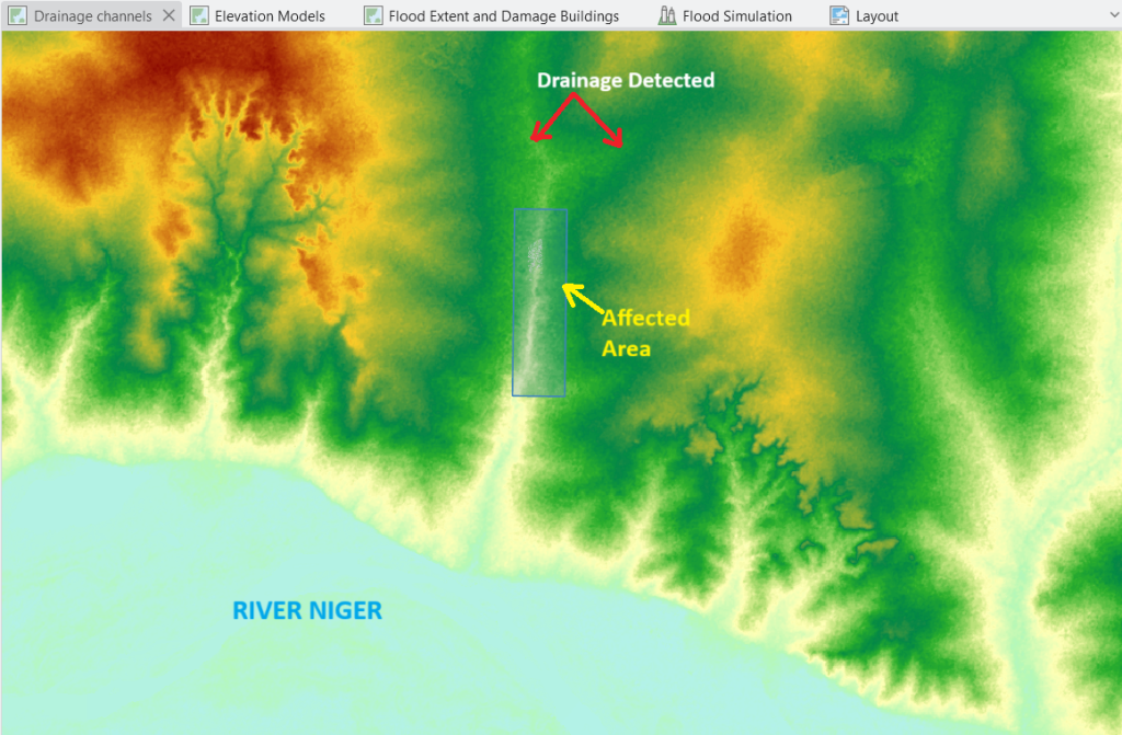
GIS Analysis: Connecting the Dots
The data collected by the drones is then integrated into a GIS platform. This allows Geoinfotech's experts to analyze the information in relation to various factors, including topography, rainfall patterns, land use, and river systems. By overlaying these layers of data, they can identify the key factors contributing to the flooding. For instance, the analysis may reveal that deforestation in upstream areas is increasing runoff and exacerbating the impact downstream. Similarly, poorly planned infrastructure or blocked drainage systems could be identified as contributing factors.
Identifying Root Causes and Potential Solutions
Geoinfotech's analysis isn't just about understanding what happened; it’s about identifying how to prevent future disasters. The GIS modeling allows for scenario planning – simulating the impact of different interventions, such as:
- Improved Drainage Systems: Identifying optimal locations for new drainage channels or upgrades to existing infrastructure.
- Reforestation Initiatives: Pinpointing areas where reforestation efforts can help reduce runoff and stabilize slopes.
- Land Use Planning: Recommending changes to land use regulations to prevent construction in flood-prone areas.
- Early Warning Systems: Integrating rainfall data and flood models to create more accurate and timely early warning systems.
A Paradigm Shift in Disaster Response
Geoinfotech's approach represents a significant shift in disaster response. By leveraging cutting-edge technology, they are moving beyond reactive measures to proactive solutions. This data-driven approach allows for more informed decision-making, leading to more effective mitigation strategies and ultimately, a more resilient community. The success of this project in Mokwa sets a precedent for other regions facing similar challenges across Nigeria and beyond. It demonstrates the power of geospatial technology to not only understand the impact of disasters but also to pave the way for a safer and more sustainable future.
Looking Ahead
Geoinfotech is committed to continuing its work in Mokwa and other communities affected by flooding. They plan to develop a comprehensive flood risk management plan that incorporates their findings and recommendations. This plan will serve as a roadmap for local authorities and stakeholders to build a more resilient future for the region.